Swann's Loop |
|
|
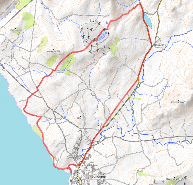
| Location: Buncrana Grade: Intermediate Distance: 25km Ascent: 400m Terrain: Varied |
| Link: https://www.strava.com/routes/26663311 |
| Route Description: |
| Start in the coastal resort of Buncrana, at the car park (Gr C 343 324) at the Crana Estuary. There is a nice cafe (Fisherman’s Wharf) nearby, on Church St (just above the Lake of Shadows hotel), for refreshments,
at the start or end, or both! There are currently no restrictions on
cyclists on the Ned’s Point path, but it is very popular with
walkers, so show extreme courtesy, and we might keep it that way.
There is a “No Cycling” sign at the upper entrance to Swann Park,
so if it is busy, avoid it and finish the loop by road, if it is
quiet, you might be OK, but dismount where there are other walkers.
Terrain Coastal path, beach, minor roads, unsurfaced mountain track, grassy path. Major ascent is early in the route! Combining a fine coastal path, with rough mountain tracks, a bit of “bush wacking”, and a beautiful riverside park, this route has everything. The Route Park as above, near the old bridge over the river Cranagh at GR C344 326. On the far side of this, turn right of Buncrana Castle, and immediately left of O'Doherty’s Keep, on a good footpath, which soon leads down to the shore of Lough Swilly. Follow the concrete coastal path past Ned’s Point, (a Napoleonic Fortress), and Father Hegarty’s Rock, until you reach the beach at Stragill. Please dismount, or display extreme courtesy to pedestrians on this busy path. Cross the beach to GR 325 348, and at the far side, take the road running inland, and go left at the first crossroads, turning right again at the Loreto Convent junction, (Gr 318 356), turning inland, to a minor cross roads at Gr 324 364. Go straight through, uphill, and turn left at the next T junction (at Linsfort), taking the first right at Gr 326 368, climbing past a standing stone on the left, and crossing the Aghaweel River (unimpressive flow!) climbing to a junction at Gr 334 377. Turn right and almost immediately left, into a lung busting pedal up a track to the wind farm on Drumlough Hill. The climb is worth it, as soon, you are up amongst a forest of whirling windmills, with the distinctive profile of Bulbin (pronounced Bulabagh locally) Hill on your left. Pass the lake on your right, and take the first turn right at Gr 363 399, to circumnavigate, and descend,( delightfully) Beam Hill to another junction at Shandrim Gr 372 380. The views of the Mintiaghs, Slieve Snaght(Monarch of Inishowen) Sl.Main are magnificent from this elevated track, the descent of which is not steep enough to distract the rider from the magic of his/ her surroundings! Descend SW to the main Road R238, but avoid it by using the yellow alternative( the L7011), which becomes a narrow grassy path at Gr 373 365, just short of Drum. This can be heavy going for a kilometre or so, but it improves and rejoins the main R238, which is followed, crossing the River Crana, to Gr 349 328, on the fringes of Buncrana. Turn right,(signposted Dunree) cross a bridge, and consider the possibility of entering Swann Park on the left. There are “No Cycling” signs, but if no one is about!! ... And you can always wheel the bike! It is a lovely place, a shame to miss, and will bring you back to the bridge close to the carpark. |
| Comments |
No Comments have been added so far. |
Back to Inishowen Peninsula Routes | Back to Guidebook | Back to Home Page |