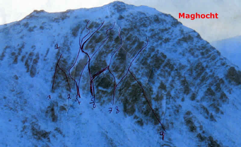
Editor: Winter Routes. Mac Uchta. | |
What would you like to do today? | |
| < | |
Crag Profile: Winter Routes. Mac Uchta. |
|||
Details of the crag can be reviewed below. Editing links are present on all routes and inter-route notes |
|||
|
|
|||
Directions: Leave the main Errigal Road, R251 at Carlaghmohane Bridge @ Grid Ref B 953205. On foot follow old access road for Altan farm for 200 mtrs until it turn right sharply, the leave road and turn West travel past Crystal rock until you reach the North face of Mac Uchta. OS Grid Reference: B942216 Click here to view location in Google Maps |
|||
1 - Op out Ridge
Length: 100m M Boner 29/12/09 Climb up most eastwardly ridge on good rock and snow with some thin ice it is in 3 pitches with small scrambling between pitches. View Route Edit Route Upload a new photo for this route | |||
2 - Y Ridge
Length: 80m M Boner 29/12/09 Start at entrance to central gully and scramble on to several small ledges to get up on main ridge follow spine until connecting with Op out ridge and finish as same View Route Edit Route Upload a new photo for this route | |||
3 - Central Gully
Length: 160m M Boner 02/01/10 Start same as Y ridge climb up left side of wide gully on good snow until small break between Y ridge and a large wall like ridge that run up middle of main gully of face ,follow up this into another wide gully that runs parallel with wall like ridge this gully steepens at it top and on to easier ground in main gully to near top where there are optional exit View Route Edit Route Upload a new photo for this route | |||
4 - Wall Ledge
Length: 160m M Boner 28/12/09 Start same as Central Gully follow up right side of wide gully past break in wall ridge and follow up left of wall ridge on steepish wide ledge until small snow bank and trend right up steep gully wall on mixed rock and frozen turf to small face at crest of next ridge A tricky rock step back slightly to left and exit up steep narrow Chute to easier ground and scramble to top View Route Edit Route Upload a new photo for this route | |||
5 - Twin Step Gully
*
I Length: 180m M Boner 30/12/09 Start at next gully to the right of wall Ledge ,follow up slightly wide gully on good snow until steep rock step into narrower gully on mixed ice and rock until it widens again with snow Follow up until crossing of wall ledge route and staying left of gully climb a short steep snow wall on poor snow and traverse right into central gully carry on up easier ground C Gully and exit as per Central Gully View Route Edit Route Upload a new photo for this route | |||
6 - Step Diversion
Length: 180m M Boner 27/12/09 Start as Twin step follow to snow gully to 1st step and turn right and climb up right hand bank of Gully on rock and frozen turf to crest of main ridge in face scramble leftward over grassy ledge to snowy wide slope on right and climb up this steep face to a ledge with frozen turf/rocks and turn left at cliff edge into a slope of mixed ground to exit View Route Edit Route Upload a new photo for this route | |||
7 - 2009 Exit
*
II Length: 180m M Boner 01/01/10 Start in next gully to right of Twin Step Gully .Climb up narrow steep gully on Mixed Rock and Ice to a widen snow slope keep left and climb another narrow gully on good ice until it meet step diversion route .Finish as per Step diversion View Route Edit Route Upload a new photo for this route | |||
8 - 2010 Entry
Length: 200m M Boner 31/12/09 Same start as "2009 exit" but divert right before 2nd gully up a steep gully bank on rock and frozen turf to crest of adjacent ridge scramble rightward in to a wide snow slope which leads to a narrow snow filled ledge with some exposure traverse ledge until it comes to easier ground and turn left and exit on mixed ground View Route Edit Route Upload a new photo for this route | |||
9 - Stphen's Ridge
Length: 200m M Boner 26/12/09 50 mtrs further right from start of 2009 exit and much lower is start of this ridge climb on to ridge on good rock some patches of ice and snow until meeting with 2010 entry route finish as per 2010 entry. View Route Edit Route Upload a new photo for this route | |||

