Malin Headcase |
|
|
| Location: Malin Head Grade: Intermediate Distance: 25km Ascent: 350m Terrain: Minor roads/tracks |
| Link: - |
| Route Description: |
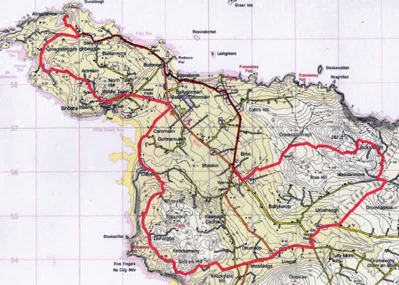
| The Ride This route links the high points of the Malin Head area, the Knockmany Bens scenic route, and the ascent of Crockalough. The route can be started either at Farrens Bar, or the Seaview Tavern/Restaurant at Ballygorman. Tea, coffee, or something stronger available at both hostelries. Terrain Mainly on surfaced minor roads and lanes, there is one substantial ascent to Crockalough followed by some rough track in descent. Route From Farrens Bar Gr C 420 581, the most Northerly pub in Ireland,follow a track over a ditch and join a grassy path linking with the coastal road Eastwards past the Seaview Tavern. There are fine views over the Garvan Isles and the more distant Inistrahull. Keep right at the left turn for the “Wee House of Malin” and follow the Inishowen 100 signs, continuing over the hill to the crossroads at Bree (Mullins shop for Provisions). Turn sharp left, and after a short distance turn left at Gr C 437 557, continue past some houses, and make the gradual, then steeper, climb towards the air traffic control dome on Crockalough. Turn right at Gr C 439 564, where the track gets rougher,(and indeed is frequently flooded), as you pass a small lake, before cresting the hill, with magnificent views opening up over the coastline and Inistrahull Island. Descending East, then South, the track continues to deteriorate as it becomes more of a watercourse, with consequent erosion, until you meet another track just east of Meedanmore, at some sheep pens Gr C 468 557. Go left and immediately right, and that track continues down to meet the road again. Turn right to a T junction, then left, crossing Hugh Roe’s Bridge. Take the first rightwhich will lead westwards, joining the main road at O’Doherty’s pub (expect traffic here) and continuing a few hundred metres before leaving to the right, and climbing gradually past Soldiers Hill and onto the most scenic section of the Inishowen 100. Pause at the car park atop the Knockmany Bens,to admire the stunning view over Five Fingers Strand, Isle of Doagh, indeed the whole Inishowen coastline and beyond to Tory Island! This well surfaced side road continues down to the rustic hamlet of Culoort, skirting the storm beach, before turning inland, over a small bridge, towards Ballygorman. Turn left at the T junction by the school, and fork left at the Crossroads Inn, past Malin Coastguard Radio Station, Middle Town, and West Town on the Malin Head Coastal loop. It is worth a diversion, turning left at Gr C 400 591(Signposted) up to Bamba’s Crown, an old fortification, and fine and popular viewpoint, (all the better if the Cafe Bamba van is on site, as they serve excellent coffee and homemade bakery products). Rejoin the coastal loop, and continue past the antique shop and harbour at Portmore, to your final destination. A slightly shorter option, which is partly “off tarmac”, is to follow the track through North Town, over the hill to Ballyhillin |
| Comments |
No Comments have been added so far. |
Back to Inishowen Peninsula Routes | Back to Guidebook | Back to Home Page |