Editor: Mountain Bike routes Inishowen | |
What would you like to do today? | |
| < | |
Crag Profile: Mountain Bike routes Inishowen |
|||
Details of the crag can be reviewed below. Editing links are present on all routes and inter-route notes |
|||
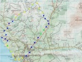
Directions: The rides included in this guide are largely non technical excursions into the most remote and beautiful places in Inishowen, and they vary in length from under 2 hours to much longer, with as much ‘off road’ as I could manage. I have tried to include worthwhile refreshment stops, but this has not always been possible due to the remoteness of the terrain. Google ‘Mountain Biking in Ireland’, and little or nothing refers to the northwest area, with the exception of Trailbadger. This site gives useful information on the various forestry areas, along with a number of routes, many of which are covered in some form in this guide, with the notable exception of the ascent and descent of Errigal (which I feel is both pointless and irresponsible). There is a Donegal Mountain Biking club, with its own Facebook page. Using this guide Apparently Ireland has a higher percentage of roads per inhabitant than anywhere else in Europe, which means that our thoroughfares tend to be less used, and indeed less maintained. Whilst our nearest neighbour Scotland has relatively few roads, and most of these are therefore busy, it has many more rough trails. These are relatively rare in Ireland and, of the ones we have, our forestry trails are probably the most accessible. This guide endeavours to utilise our dense network of minor roads with a variety of off road trails, to visit some of the most interesting places in our rural landscape. These routes are rarely technical, so colours are used to indicate terrain ‘under wheel’, rather than as a guide to difficulty. Colour Coding. Blue. Surfaced, at least to some extent, possibly liberally laced with rushes or grass. Yellow. Easily cyclable, eg forestry standard gravel track, or custom built walking or cycling trail. Orange. Heavier going, boggy, rocky, or muddy track. Green. Grass or sand Black. Difficult, steep, technical. OS Grid Reference: Sheet 3 Click here to view location in Google Maps |
|||
1 - Isle of Doagh
Length: 13m AT
Isle of Doagh
Inishowen Peninsula, Co.Donegal. Map OS 1:50,000 Sheet 3
The Ride.
This is ideal for a short winter’s day. The route gives spectacular
sea views over Pollan Bay and Glashedy Island, and starts from the
comfortable surroundings of the Strand Hotel, Ballyliffin GR C 386
484.
Terrain
Along the back of the beach it starts grassy, but conditions
‘underwheel’ will vary, and include sand and round stones. Beyond the castle it is on
quiet roads with lovely views. Largely level and hills are
short.
Time 1.5 hours; Distance 13 kilometres; Ascent
100m.
Approach.
Through Buncrana, and Clonmany to Ballyliffin on
the R238.
Route
Park at the Strand HotelBallyliffin, and
freewheel pleasantly down the hill in a northward direction to the
carpark at the beach Gr C 387 495. A grassy track along the back of the dramatic Pollan
Strand, makes delightful level pedalling for about 2.5 kilometres,
with splendid sea views, to meet the end of a track at
Carrickabraghy. From time
to time (particularly in winter) the track gets inundated by stones
driven up by the thunderous waves, and can become more
challenging. If the tide
is out, it might be easier to bike along the sand, where possible. It
is worth stopping at the castle to acquaint yourself with its
interesting history, and perhaps view the blow hole in the rocks
beyond. The road climbs past the old castle before
descending to Lagacurry (the Famine Village there is worth a visit),
with good views over the Lagg (Narrows) and the Knockmany Bens on the
other side. Turn inland to
Claragh, take the first left, and descend again to the shore at
Doaghmore. This scenic
little road follows the coastline around the east side of Doagh
Island, with a couple of short hills, to rejoin the main (Well,
mainer!) road at GR C 422 498, and then the proper main road at GR C
407 489 (Lackboy). Two kilometres on this quite busy thoroughfare will bring you back to the
Strand Hotel. There is a good coffee shop, Nancy’s Barn, serving award winning chowder just
as you enter Ballyliffin.
View Route Edit Route Upload a new photo for this route | |||
2 - Culdaff Antiquities
Length: 25m AT
Culdaff Antiquities
Inishowen, Co. Donegal. Map OS 1:50,000 Sheet 3
The Ride
This is an interesting area, full of antiquities, which can be
linked together by tracks and quiet lanes through old “Off the
beaten track” communities. There are fine views, coastal, hill and
moor, very little traffic, and the trip starts, and ends, at McGrorys,
a small family run hotel, famous for its hospitality, music and
food.
Terrain
Minor roads, lanes and unsurfaced tracks, any hills are very short!
Time . 2- 2.5 hours Distance 25km
Route.
Departing from McGrorys, turn left and follow the coastal road (a Sli
na Slainte) along the river and the beach carpark/ childrens’
playpark.. Follow the coastal road past a caravan park, until it turns right, and at this
point, follow the road back uphill, until it joins the Culdaff/
Carrowmena Road. Turn left, and continue along the road for approx 1.5
kilometres, past some mushroom houses on the right, and turn left
again, (approx 30 mins from Culdaff) up a lane to Watch Hill (approx
400 metres after emerging on the road) at GR 562 483.
The next section is an intricate network of tracks through “claghans”,some abandoned, some still
occupied. The laneway twists through some ruined cottages, joining
another lane at GR 566 484, where you turn right, then first left,
beside a cottage GR 565 483, to the next T junction. Follow this
minor tarmaced lane left (north east) towards Bootog to a right
angled turn , and then to another T junction at GR 576 478. Turn
left, and continue down to another sharp bend at Crockaveela, after
which there are more ruined cottages and a further T junction at GR
582 475. This time, go right, then first left (opposite Tremone
sign) at GR 580 475, and continue through the hamlet of Ballycharry,
to GR 585 469, where the Darcy Magee path is picked up, leading,
over a footbridge, and into the picturesque village of Carrowmena,
beside the Tremone Bar. (On this track there is an ancient slab
cross at GR 58763 46816). Turn right, through the village,
and fork right, to the crossroads at Falmore.GR 584 452. Go straight
through, and fork right, turning right, (downhill), again at GR 574
449. This remote track takes you through Tirahork and Cambry, and
you turn right at the T junction, uphill and first left to arrive at
Glacknadrummond Church, GR 547 473. This area is full of megalithic
remains. Turn left at the church, downhill, and straight through the
crossroads past Temple Hill (Black Hill on the map) to the ancient
church of Clonca, and the high cross, on the right. Turn right here
(worth stopping to look at the cross, and the earliest known engraving
of a hurling stick within the church) and continue back to the main
road at yet another chapel (Bocan). It is worth a slight diversion
here, back to the right, to see the famous Bocan Stone Circle at GR
476 542, but otherwise turn left, and follow the main road less than a
kilometre to McGrorys.
Add route description here... View Route Edit Route Upload a new photo for this route | |||
3 - Malin Headcase
Length: 25m AT
Malin Headcase
Inishowen, Co Donegal. Map OS 1:50,000 Sheet 3
The Ride
This route links the high points of the Malin Head area, the Knockmany
Bens scenic route, and the ascent of Crockalough. The route can be started either
at Farrens Bar, or the Seaview Tavern/Restaurant at Ballygorman. Tea, coffee, or something
stronger available at both hostelries.
Terrain
Mainly on surfaced minor roads and lanes, there is one substantial
ascent to Crockalough followed by some rough track in descent.
Time 3 hours; Distance 25k approx; Ascent 350m.
Approach.
Through Carndonagh and
Malin Town to Ballygorman on the R238 and R242.
Route
From Farrens Bar Gr C 420 581, the most Northerly pub in
Ireland,follow a track over a ditch and join a grassy path linking
with the coastal road Eastwards past the Seaview Tavern. There are
fine views over the Garvan Isles and the more distant Inistrahull.
Keep right at the left
turn for the “Wee House of Malin” and follow the Inishowen 100
signs, continuing over the
hill to the crossroads at Bree (Mullins shop for Provisions). Turn sharp left, and after a
short distance turn left at Gr C 437 557, continue past some houses,
and make the gradual, then steeper, climb towards the air traffic
control dome on Crockalough. Turn right at Gr C
439 564, where the track
gets rougher,(and indeed is frequently flooded), as you pass a small
lake, before cresting the hill, with magnificent views opening up over
the coastline and Inistrahull Island. Descending East, then
South, the track continues to deteriorate as it becomes more of a
watercourse, with consequent erosion, until you meet another track
just east of Meedanmore, at some sheep pens Gr C 468 557. Go left and immediately right,
and that track continues down to meet the road again. Turn right to a T junction,
then left, crossing Hugh Roe’s Bridge. Take the first rightwhich will lead westwards,
joining the main road at O’Doherty’s pub (expect traffic here) and
continuing a few hundred metres before leaving to the right, and
climbing gradually past Soldiers Hill and onto the most scenic section
of the Inishowen 100.
Pause at the car park atop the Knockmany Bens,to admire the
stunning view over Five Fingers Strand, Isle of Doagh, indeed the
whole Inishowen coastline and beyond to Tory Island!
This well surfaced side road continues down to the rustic hamlet of
Culoort, skirting the storm beach, before turning inland, over a small
bridge, towards Ballygorman. Turn left at the T junction by the school, and fork left at the
Crossroads Inn, past Malin Coastguard Radio Station, Middle Town, and
West Town on the Malin Head Coastal loop. It is worth a diversion, turning left at Gr C 400
591(Signposted) up to Bamba’s Crown, an old fortification, and fine
and popular viewpoint, (all the better if the Cafe Bamba van is on
site, as they serve excellent coffee and homemade bakery
products). Rejoin the coastal loop, and continue past the antique shop and harbour at
Portmore, to your final destination. A slightly shorter option, which is partly “off
tarmac”, is to follow the track through North Town, over the hill to
Ballyhillin
View Route Edit Route Upload a new photo for this route | |||
4 - Inishowen Head
Length: 14m AT
Inishowen, Co Donegal Map OS 1:50,000 Sheet 3
The Ride. This very hilly route, follows part of the “Inishowen Scenic Loop” on a good track, before it “takes off” on a turf cutter’s track across the bog. The second half of the route is a long climb and descent on a minor tarmac road. Due to its elevation, there are extensive views across the mouth of the Foyle, North Derry and Antrim coasts.
Terrain. Mostly good tracks, but also a section of boggy terrain. Time 2-2.5 Hours, Distance 14 Km
Approach From Derry to Moville/ Grrencastle, following the higher road towards Shroove to the Drunken Duck Pub.
Route From the Drunken Duck ( Sheet 3; Gr C 673 425), follow the road North East for less than a kilometre, turning up hill at Gr C 680 430 (where the main road turns back South downhill to the beach/lighthouse). A substantial climb takes you up to the old wartime lookout post on top of Inishowen head, and the track continues past the picnic area/information board (where St Columba left Ireland for Iona, and climbed the hill for a last look at Derry and the “Auld Sod”), in a North West direction, before turning SW at Gr C 660 452, and going uphill again. The track has been badly damaged here by quads and 4x4s, but is still passable.
Ignoring one turn to the right (to an isolated shed) turn right at Gr C 655 446 onto bog tracks over Glenane Hill, keeping left and continuing to a gate/wall. The track continues on the other side to Craig. Out of courtesy, stop and say “thank you” at the first house on the right (The Music House), when you go through the second gate. The lane you just came down is private, and belongs to Mr. Anthony McHendry, a musician and generally hospitable man.
A long climb from Craig, leads over Barnes Hill/Crockmore, and descending, take the left fork at Gr C 641 426, turning downhill again at Gr C 649 428, and first left again (at Gr C 650 424), finally descending to Tawnawaddy. Turn left, and just over two kilometres along this elevated road will lead back to the “Drunken Duck”, which hopefully will be open!
View Route Edit Route Upload a new photo for this route | |||
5 - Swann's Loop
 D -
D -Length: 25m AT . Inishowen, Co. Donegal. Map OS 1:50,000 Sheet 3
The Ride Start in the coastal resort of Buncrana, at the car park (Gr C 343 324) at the Crana Estuary. There is a nice cafe (Fisherman’s Wharf) nearby, on Church St (just above the Lake of Shadows hotel), for refreshments, at the start or end, or both! There are currently no restrictions on cyclists on the Ned’s Point path, but it is very popular with walkers, so show extreme courtesy, and we might keep it that way. There is a “No Cycling” sign at the upper entrance to Swann Park, so if it is busy, avoid it and finish the loop by road, if it is quiet, you might be OK, but dismount where there are other walkers. Terrain Coastal path, beach, minor roads, unsurfaced mountain track, grassy path. Major ascent is early in the route! Combining a fine coastal path, with rough mountain tracks, a bit of “bush wacking”, and a beautiful riverside park, this route has everything. Time 3-4 hours. Distance 25Km Approach From Derry Londonderry along the shores of Lough Swilly to Buncrana.
Route Park as above, near the old bridge over the river Cranagh at GR C344 326. On the far side of this, turn right of Buncrana Castle, and immediately left of O'Doherty’s Keep, on a good footpath, which soon leads down to the shore of Lough Swilly. Follow the concrete coastal path past Ned’s Point, (a Napoleonic Fortress), and Father Hegarty’s Rock, until you reach the beach at Stragill. Please dismount, or display extreme courtesy to pedestrians on this busy path. Cross the beach to GR 325 348, and at the far side, take the road running inland, and go left at the first crossroads, turning right again at the Loreto Convent junction, (Gr 318 356), turning inland, to a minor cross roads at Gr 324 364. Go straight through, uphill, and turn left at the next T junction (at Linsfort), taking the first right at Gr 326 368, climbing past a standing stone on the left, and crossing the Aghaweel River (unimpressive flow!) climbing to a junction at Gr 334 377. Turn right and almost immediately left, into a lung busting pedal up a track to the wind farm on Drumlough Hill. The climb is worth it, as soon, you are up amongst a forest of whirling windmills, with the distinctive profile of Bulbin (pronounced Bulabagh locally) Hill on your left. Pass the lake on your right, and take the first turn right at Gr 363 399, to circumnavigate, and descend,( delightfully) Beam Hill to another junction at Shandrim Gr 372 380. The views of the Mintiaghs, Slieve Snaght(Monarch of Inishowen) Sl.Main are magnificent from this elevated track, the descent of which is not steep enough to distract the rider from the magic of his/ her surroundings! Descend SW to the main Road R238, but avoid it by using the yellow alternative( the L7011), which becomes a narrow grassy path at Gr 373 365, just short of Drum. This can be heavy going for a kilometre or so, but it improves and rejoins the main R238, which is followed, crossing the River Crana, to Gr 349 328, on the fringes of Buncrana. Turn right,(signposted Dunree) cross a bridge , and consider the possibility of entering Swann Park on the left. There are “No Cycling” signs, but if no one is about!! ... And you can always wheel the bike! It is a lovely place, a shame to miss, and will bring you back to the bridge close to the carpark.View Route Edit Route Upload a new photo for this route | |||
6 - North Polar Challenge
Length: 22m AT
Inishowen, Co Donegal. Map OS 1:50,000 Sheet 3
The Ride
Containing an unusually large amount (for Ireland) of non
tarmac biking, and great views, this route is a real cracker! In effect it is a largely
“off road” circuit of the distinctive Bulbin Hill, visiting remote
communities tucked away amongst spectacular mountain scenery. The North Pole Bar is the hub
of a very active cycling club based at Drumfries, (evidenced by the
many “Cyclists” Signs thereabouts!). It is also the start (or finish) of the ‘Irish
Polar Challenge’, a bike ride connecting this establishment with Tom
Crean’s South Pole Bar on the Dingle Peninsula, Co.Kerry. If open, stop for a pint, coffee
or whatever! There is also the community run Slieve Snaght Centre
which provides snacks and even a shower (when open).
Terrain.
Mainly gravel and bog tracks. One ‘off-track’descent of a hillside.
Time 3 hours; Distance 22 Kilometres; Ascent 500m.
Approach.
Through Derry/Londonderry and Buncrana to Drumfries, on the
Clonmany/Carndonagh Road (R238).
Route.
Start at the North Pole Bar, Drumfries, on the Buncrana to Carndonagh
road (Sheet 3, Gr C 385 390) on Inishowen. Follow to R244 towards Carndonagh but after
barely 100m, leave it, keeping right, up a minor road,straight up a
hill. Through a couple of gates, the road becomes un tarred track, bypassing on its right, the
volcanic plug of Barnanmore. After 3 km, at Gr C 410 419, dog leg left and rejoin the R244. Turn left and immediately right, skirt the shore of L.Fada, and descend to join the Clonmany
road. Turn left at Gr C 388 448, onto a more minor parallel road, and first left again onto a
narrow lane. The first lane on the right is a dead end, but take the second at Gortnamona,
keep left at a fork to a minor T junction. Right, then left at a fork, towards the striking hill
of Bulbin.
After about 1.5 Km at Gr C 367 436, turn right along a lane, and go
left up the track that climbs along the SW slopes of the
mountain. Just beyond the high point at Gr C 352 414, a track branches left out along the
spur. This is rough and muddy but very cyclable.
At its end, a rutted turf track descends towards the valley. Take this, and
follow tractor tracks southwards and down hill, avoiding turf banks
and the odd swamp, to join the main track that crosses this remote
mountain side. (Perhaps not so remote with the big wind farm just beyond the track!). Turn left, try to ignore the fly tipping, and after 1.5 km, just after the track swings right, turn
left and descend steeply back onto the R286 Buncrana to Clonmany
road. A 2 kilometre pedal will bring you back to the North Pole at Drumfries.
View Route Edit Route Upload a new photo for this route | |||
7 - Around Inch Island.
Length: 32m AT
Burt, Co.Donegal. Map 1:50,000 Sheet 7
The Ride.
This is an attractive route on minor trails and roads, no more than 20
minutes from Derry, taking in the island, over 3 embankments, and a
nature reserve via an old railway line.
Terrain.
The route is mainly on minor roads and good tracks, and there are few
hills.
Time 3.5 hours, Distance 32k; Ascent 100m
Approach
From Derry/Londonderry towards Letterkenny.
Start at Kernan\'s cafe on the main Derry/Letterkenny Road N13 at
Newtowncunningham. Gr C 311 167.
Route.
Continue out towards Letterkenny
to the end of the village, turning right at Gr C 304 167. Take the first right turn,
approx 1k along this road, and continue to the end of the road to the
Blanket Nook railway embankment, which is crossed on a narrow grassy
track, going rightwards under an old bridge at the far end. Turning uphill, there is an old
graveyard on the right (worth a visit) and beyond this, keep left and
left again, to round Finwell Hill on its North side. Continue downhill to the
junction at Gr C 327 206, turn left through Carrowen to the newly
renovated Farland Bank amenity area/carpark. A good gravel track across
this, leads to Inch Island and along the shore to a new car park on
the lake side, from which the road can be accessed at Gr C 345 232.
Either continue on the track to the main causeway or turn left, and
begin a clockwise circumnavigation of the Island. The road climbs past Inch
Castle, and descends to the scenic Mill bay. You can either cross the
Island on a minor road at this point, or continue around the coast to the road end at
Binalt.
There used to be a track connecting Binalt to Inch Fort,(still marked on some maps) but
this is now sadly overgrown. A circuit of Inch can still be made by
crossing a couple of fields just below it, and to do this, go up a
lane just before the road end, which turns and runs parallel to the
coast. At a gate, go into a field (you will see the overgrown track
above on your right), cross the field and another to gain a track at
the far end, which leads to a minor road and thence to the road just
above the pier.Turn right, and take the coastal road, which is joined
by the short cut after about 3 km. Cross the causeway, and keep
right at the other side, towards Burnfoot. A new track almost immediately leads off to the right. There is a wonderful footpath (renovated railway embankment
with bird watching hides) leading all the way back to the Farland Bank. Show extreme
courtesy to pedestrians, as this is heavily used! Retrace your route through
Carrowen, keeping right at the first fork, through the crossroads, and
turn sharply right at Gr C 328 198, towards the prominent Burt Castle
on the hill. The route
circles the hill to the North and West, before taking off SW, on a
couple of \'dog legs\' to join the main Derry Letterkenny road(N13)
just East of Kernans Filling Station/Cafe.
View Route Edit Route Upload a new photo for this route | |||
8 - Crock of Onions
Length: 20m AT
Inishowen, Co.Donegal Map OS 1:50,000 Sheet 3
The Ride
This explores the high ground of bog and moor that bounds the Foyle on
its western side. Some quiets roads, but much of it on elevated track
and trail with views across Inishowen, and the river Foyle Basin.
Terrain
Largely quiet roads and ‘forestry quality’ tracks, but after Lough
Fada there is a crossing of open bog (about 500m) to link up with a
tricky rutted track which descends back to Gleneely.
Time 2.5 hours, Distance 20 Km
Approach
From Derry to Carndonagh on the R240, then the R244 to Gleneely
Village. Parking available outside the football club.
Refreshments available at The Carraig Bar or The Orchard Bar.
Route
From Gleneely take the Redcastle Road, pass a church on the left, and
take the next minor road, also on the left. After about 2 Km, at a minor crossroads, turn right
onto a forestry track Gr 564 423, which climbs gradually, becoming
rougher past the forestry.
Where this leads back onto tarmac, turn left downhill, towards
the Foyle for just over a kilometre, before turning right at Gr 586
396. This minor road jiggles its way across the hill with lovely views up
the Foyle towards Derry to a T junction at Gr 572 379. Turn right, up
the hill, and follow this track for about 3.5 km across wild bogland
until the track is joined by another from the left, then meets the
main road close to the watershed. A short climb leads to the top of the hill known locally as
Crock An Onion (shown as Rowantree Hill on the map). Just before the viewpoint
carpark, turn left onto another track. Continue along the top of the hill, ignoring any fly
tipping as best you can, and passing Lough Fada on your left, until
the track runs out. There is about 500m of open bogland to cross to reach the beginning of the
next track, but this is fairly level, and there are tracks to follow
to a badly eroded area of turf cuttings at Gr 534 410, where the other
track starts. This track is basically two ruts, divided with moss and rushes, but it is firm,
and goes downhill for about 4 Km, eventually improving after a wire
gate, and arriving back in Gleneely, by either turning right and left,
or continuing straight on to the main road from Carndonagh, then right
to the village.
View Route Edit Route Upload a new photo for this route | |||
9 - Lough Inn
Length: 10m AT
Inishowen, Co.Donegal. Map OS 1:50,000 Sheet 3
The Ride
This is a short route circumnavigating an upland lake. Starting at the lake’s west
end, it passes the lough on its northern side on a track, descends
towards Lough Foyle, before doubling back, up the hill on a minor road
and taking the eastern shore.
Terrain
Stony track and minor road. Hilly.
Time 1-1.5 hours. Distance 10km
Approach
From Derry follow the main road toward Moville, turning left at Gr 535
337 And following the L.Inn Carndonagh Road to the far end of the
Lough, where the road is joined on the right by a track Gr 511394
The Route
Follow the rough track in an easterly direction along the north side
of the lake, and climb over a col, before descending to join a tarmac
road, which continues down hill to meet the approach road to Lough Inn
(from the Derry Moville Road).
Turn right, and climb gradually over the watershed, pass the
lake, and back to the car.
View Route Edit Route Upload a new photo for this route | |||
10 - Inishowen WildWay (Mountainbike Route)
Length: 80m AT Inishowen, Co Donegal. Map 1:50,000 Sheet 3
The Ride This is a cycling version of the Inishowen Wildway, a conceptual project to walk the Irish coastline from Buncrana to Moville, connecting the two ferries. The walkers route has been restricted, in that the entire Malin area has been left out, due to chronic access problems, and the mountain bike route has also been so diverted to avoid contentious areas.
Terrain
Time Distance 80+ Km
Approach From Derry/Londonderry to Buncrana ,along the Swilly, and park near the old bridge over the river Cranagh at GR C344 326.
The Route On the far side of this, turn right of Buncrana Castle, and immediately left of O'Doherty’s Keep, on a good footpath, which soon leads down to the shore of Lough Swilly. Follow the concrete coastal path past Ned’s Point, (a Napoleonic Fortress), and Father Hegarty’s Rock, until you reach the beach at Stragill. Please dismount, or display extreme courtesy to pedestrians on this busy path.
Cross the beach to GR 325 348, and at the far side, take the road running inland, and go left at the first crossroads, turning right again at the Loreto Convent junction, (Gr 318 356), turning inland, to a minor cross roads at Gr 324 364. Go straight through, uphill, and turn left at the next T junction (at Linsfort), taking the second left, just past Ballyannan Br. Follow this very minor road for a kilometre, and take the first right ,(just after crossing a stream) climbing this lane to a T junction at Gr314 390. Turn left and take the scenic tour of Tonduff Hill (interesting megalithic tomb on top). At the next junction turn right, keep left, and descend to Gr 297 395, where a sharp right is taken, descending, crossing the Owenerk River, and following the delightful road, past Milltown and Carha, which traverses the South Eastern slopes of the Urris Hills.
Emerging on the Mamore Gap road, turn left, and a steep climb takes you to the top, rewarding views, and an even more rewarding descent on the other side lead down to a car park at Gr 318 443. The hard work really starts here! Follow the newly surfaced track which wends its way unrelentingly uphill to the col between Mamore Hill and Crockmain. It runs out at the top, but there is a fainter trail leading East to the col between Crockmain and Slievekeeragh, which can be mostly cycled as it is either level or downhill, and there are yellow posts to roughly mark the route. Soon you pick up the Butler's Glen track, which exits onto the road at Glen House (food and refreshments). Turn right, and follow the road into Clonmany.
From the square, take the road uphill towards Ballyliffin to a cross roads at Gr 380 473. Turn left, towards Annagh, but keep right, and the road takes you down to the beach at Pollan, Gr 387 495. A grassy track along the back of the beach, makes delightful level pedalling for about 2.5 kilometres, with splendid sea views, to meet the end of a track at Carrickabraghy. It can also be stony due to the effect of storms, and if the tide is out, the hard sand is probably the best option. The road climbs past the old castle of that name, before descending to Lagacurry (the Craft Village there is worth a visit), with good views over the Lagg (Narrows) and the Knockmany Bens on the other side. Turn inland to Claragh, and descend again to the shore at Doaghmore. This scenic little road follows the coastline around the east side of Doagh Island, with a couple of short hills, to rejoin the main (Well, Mainer!) road at GR 422 498, and then the proper main road at GR 407489 (Lackboy). Turn left, and suffer this relatively busy road (there are no feasible alternatives) for about 5k, turning left onto the slab road at Gr 451 468, which leads to Strawbridge on the R238. Go left, and just as you enter Malin Town, turn right past stables at Gr 471 497, on the south side of the Ballyboe River. This becomes unsurfaced before you cross the R243 Malin/Culdaff road, continue past Cracknagh, onto a minor road which leads into Culdaff village over the bridge, and left to McGrorys Hotel (food and refreshments), just past the village green. Departing from McGrorys, turn left and follow the coastal road (a Sli na Slainte) along the river to GR 536 497, past the beach carpark/ childrens’ playpark at GR 547 497. Follow the coastal road past a caravan park, until it turns right, and at this point (GR 553 497) follow the road back uphill, until it joins the Culdaff/ Carrowmena Road. Turn left, and continue along the road for approx 1.5 kilometres, past some mushroom houses on the right, and turn left again, (approx 30 mins from Culdaff) up a lane to Watch Hill (approx 400 metres after emerging on the road) at GR 562 483. The next section is an intricate network of tracks through “claghans”, some abandoned, some still occupied. The laneway twists through some ruined cottages GR 564 485, joining another lane at GR 566 484, where you turn right, then first left, beside a cottage GR 565 483, to another T junction at GR 569 481. Follow this minor tarmaced lane left (north east) towards Bootog to a right angled turn GR 572 483, and then to another T junction at GR 576 478. Turn left, and continue down to another sharp bend at Crockaveela, after which there are more ruined cottages and a further T junction at GR 582 475. This time, go right, then first left (opposite Tremone sign) at GR 580 475, and continue through the hamlet of Ballycharry, to GR 585 469, where the Darcy Magee path is picked up, leading, over a footbridge, and into the picturesque village of Carrowmena, beside the Tremone Bar, GR 591 462. (On this track there is an ancient slab cross at GR 58763 46816).
Turn left through the charming unspoiled village, in a northeasterly direction to a junction at Ballymagaraghy, keep right and continue over the hill to a T junction at the Kinnego Bay Road. Cruise downhill with great views of this superb bay opening up ahead, but at the Trinidad Valencera Memorial. you dog leg back uphill and follow this hilly coastal route (one of the tough sections of the Inishowen 100), turning left out to Craig Gr 640 453. A rough track leads over the hill here, but first you must call at the music house ( the one just past the gate) and ask permission of Mr Anthony McHenry. A small gift of cake or biscuits is always appreciated, as is a few minutes chat! Take McHenry's lane over 2 gates and out onto the hill, where turf cutters tracks lead across Glenane Hill to join a more major track at Gr 656 447. Go left, downhill on the Inishowen Head scenic Loop (badly eroded in places by quads and 4x4s) which leads eventually steeply downhill and left to Stroove. 4k along the coastal road leads into Greencastle. From Greencastle there is a lovely coastal path to Moville. It is narrow, and popular with walkers, so take care and show courtesy. View Route Edit Route Upload a new photo for this route | |||
