Culdaff Antiquities |
|
|
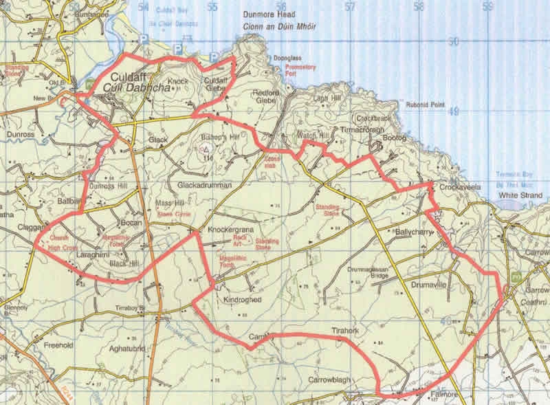
| Location: Culdaff Grade: Easy Distance: 25km Ascent: 100m Terrain: Minor roads |
| Link: - |
| Route Description: |
| The Ride This is an interesting area, full of antiquities, which can be linked together by tracks and quiet lanes through old “Off the beaten track” communities. There are fine views, coastal, hill and moor, very little traffic, and the trip starts, and ends, at McGrorys, a small family run hotel, famous for its hospitality, music and food. Terrain Minor roads, lanes and unsurfaced tracks, any hills are very short! Route. Departing from McGrorys, turn left and follow the coastal road (a Sli na Slainte) along the river and the beach carpark/ childrens’ playpark.. Follow the coastal road past a caravan park, until it turns right, and at this point, follow the road back uphill, until it joins the Culdaff/ Carrowmena Road. Turn left, and continue along the road for approx 1.5 kilometres, past some mushroom houses on the right, and turn left again, (approx 30 mins from Culdaff) up a lane to Watch Hill (approx 400 metres after emerging on the road) at GR 562 483. The next section is an intricate network of tracks through “claghans”,some abandoned, some still occupied. The laneway twists through some ruined cottages, joining another lane at GR 566 484, where you turn right, then first left, beside a cottage GR 565 483, to the next T junction. Follow this minor tarmaced lane left (north east) towards Bootog to a right angled turn , and then to another T junction at GR 576 478. Turn left, and continue down to another sharp bend at Crockaveela, after which there are more ruined cottages and a further T junction at GR 582 475. This time, go right, then first left (opposite Tremone sign) at GR 580 475, and continue through the hamlet of Ballycharry, to GR 585 469, where the Darcy Magee path is picked up, leading, over a footbridge, and into the picturesque village of Carrowmena, beside the Tremone Bar. (On this track there is an ancient slab cross at GR 58763 46816). Turn right, through the village, and fork right, to the crossroads at Falmore.GR 584 452. Go straight through, and fork right, turning right, (downhill), again at GR 574 449. This remote track takes you through Tirahork and Cambry, and you turn right at the T junction, uphill and first left to arrive at Glacknadrummond Church, GR 547 473. This area is full of megalithic remains. Turn left at the church, downhill, and straight through the crossroads past Temple Hill (Black Hill on the map) to the ancient church of Clonca, and the high cross, on the right. Turn right here (worth stopping to look at the cross, and the earliest known engraving of a hurling stick within the church) and continue back to the main road at yet another chapel (Bocan). It is worth a slight diversion here, back to the right, to see the famous Bocan Stone Circle at GR 476 542, but otherwise turn left, and follow the main road less than a kilometre to McGrorys. Add route description here... |
| Comments |
No Comments have been added so far. |
Back to Inishowen Peninsula Routes | Back to Guidebook | Back to Home Page |