Around Inch |
| Location: Mountain Bike Routes Grade: D Length: 32m |
| First ascent: Geoff Thomas, Alan Tees |
| Route Description: |
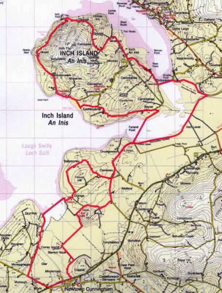
| This is an attractive route on minor trails and roads, no more than 20 minutes from Derry, taking in the island, via 3 embankments, and a nature reserve via an old railway line. Start at Kernan's cafe on the main Derry/Letterkenny Road N13 at Newtowncunningham Gr 311 167, and continue out towards Letterkenny to the end of the village, turning right at grid 304 167. Take the first right turn, approx 1k along this road, and continue to the end of the road to the Blanket Nook railway embankment, which is crossed on a narrow grassy track, going rightwards under an old bridge at the far end. Turning uphill, there is an old graveyard on the right (worth a visit) and beyond this, keep left and left again, to round Finwell Hill on its North side. Continue downhill to the junction at Gr327 206, turn left through Carrowen to the newly renovated Farland Bank amenity area/carpark. A good gravel track across this, leads to Inch Island, but it's not actually joined up to anything on the far side! A narrow path through brambles leads rightwards to wet ground on the lakeside. This is heavy cycling, or hopping between dryer patches, (made worse in wet weather by cattle), but there are no obstacles between Farland Bank and a new car park on the lake side, from which the road can be accessed at Gr 345 232. ( It may be easier to climb directly up the field at the end of the bank to the road). Turn left, and begin a clockwise circumnavigation of the Island. The road climbs past Inch Castle, and descends to the scenic Mill bay. Continue around the coast to the road end at Binalt.There used to be a track connecting Binalt to Inch Fort,(still marked on some maps) but this is now sadly overgrown. A circuit of Inch can still be made by crossing a couple of fields just below it, and to do this, go up a lane just before the road end, which turns and runs parallel to the coast. At a gate, go into a field (you will see the overgrown track above on your right), cross the field and another to gain a track at the far end, which leads to a minor road and thence to the road just above the pier.Turn right, and take the coastal road to the causeway, cross this and keep right at the other side, towards Burnfoot. At Gr 361 235 a new footbridge can be seen on the right through a gateway. When this bridge is crossed, there is a wonderful footpath (renovated railway embankment with bird watching hides) leading all the way back to the Farland Bank. Show extreme courtesy to pedestrians, as this is heavily used! Retrace your route through Carrowen, keeping right at the first fork, through the crossroads, and turn sharply right at Gr328198, towards the prominent Burt Castle on the hill. The route circles the hill to the North and West, before taking off SW, on a couple of 'dog legs' to join the main Derry Letterkenny road(N13) just East of Kernans Filling Station/Cafe. 3.5 hours, 32k, minor roads and good tracks. One section, of less than one kilometre, of boggy wet ground(should be dryer in summer). |
 Around Inch - Mountain Bike Route |
| Comments |
No Comments have been added so far. |
Route Number: 2748