An Port |
| Location: Mountain Bike Routes Grade: D - Length: 20m |
| First ascent: Not known |
| Route Description: |
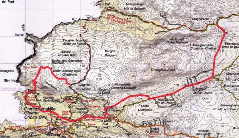
| An Port/Glen Head This is a popular route, combining part of the most spectacular sea coast in Ireland, with the special atmosphere of this most remote area of the Gaeltacht, and numerous antiquities. Approach through Ardara or Carrick to Glencolmcille, Gr 530 847. Follow the road out of the village East for 2k to a fork at Gr 552 850, where the left branch is taken, alongside the Murlin River to another fork, at Gr 588 866 (near PO). Leave the road here on a track North, crossing the river, and following the track for 2.5 k to rejoin a minor road at Lougheraherk. Turn left, and take this (now tarmaced) road down the glen towards the distant bay. Four kilometres ahead, An Port, once considered by Lonely Planet as the most remote place in Ireland, now has a carpark, and is rarely deserted at weekends or during the summer. It is worth leaving the bike here, and walking up Port Hill to view the spectacular sea stacks of Toralaydan, and Tormore, and the inaccessible Glenlough Bay beyond. Back at An Port, cross the bridge and follow the grassy track, climbing gradually to Garveross Hill, descending in a SW direction to Gr 536 863, where a right turn, and climb, has to be made, to gain the more coastal descent track from the signal tower down to Biofan and Glencolmcille. 20k, 2.5-3 hours. Minor Roads and grassy tracks. OS 1:50,000 sheet 10 |
 An Port - Mountain Bike Route |
| Comments |
No Comments have been added so far. |
Route Number: 2747