Tour De Bluestacks |
| Location: Mountain Bike Routes Grade: D - Length: 80m |
| First ascent: Kevin Deery, Alan Tees 1992 |
| Route Description: |
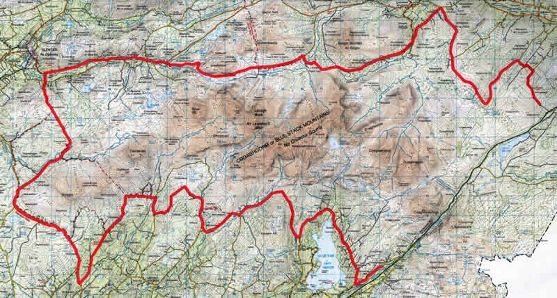
| Route 15, Tour De Bluestacks A bit of a block buster, done in 1992, starting and finishing in Biddy O Barnes. As Barnesmore Gap just gets busier and busier,( and the landowner forbids use of the old railway track) it is recommended to leave a car at the old school Gr 095 920 at Blackburn Bridge, about 2 kilometres East of Lough Mourne, as you approach from Ballybofey. Start at Biddy O Barnes Gr 020 845 on the West side of Barnesmore Gap, exit onto the main road towards Donegal Town, and take a minor road running almost parallel on the North side of the main road at gr 012 839. Follow this until it joins the Lough Eske loop road, turn right, and keep on this (anti clockwise) around the North side of the Lough until about 10 o'clock! Turn right at gr 959 848, past a small B&B and up, on a forestry track, over the North col of Banagher Hill. Cruise down the valley alongside the Eglish River, and at the T junction, turn right crossing the river, and about 2k further on, after crossing the Sruell River, bear right towards the mountains. Another 1.2 k at gr 908968, turn left onto trackks, first NW then SW, which take you back onto the road again at gr 884 860. Turn right, and take the first left, West, then South on a track onto a minor road which joins the main road (R262) at Gr 845 826. Turn right along this road for approx 6k to Sir Albert's Bridge, where you turn right and continue 2.5k to where the road forks at a bridge. Keep left, and follow signs for the 'Bluestack Way'. A long straight narrow grassy track crosses the bog (A famine road) north Westerly. Take this, and follow it down the hill, crossing a footbridge to join the R253 Glenties/Ballybofey road. Turn right along this road for 6.5k, and 1k beyond McKevitt's Bridge, turn right alongside the Owengarve River. This becomes a track and climbs over the col at Croaghubbrid following the Reelan River downhill, until just beyond a ruined school, turn right at Gr 961 942. This goes downhill towards a farm at Crolack (known in some quarters as 'Coronation Cottage'), cross the river and follow the Bluestack Way signage in a SE direction. It may be necessary to carry the bike along sections of this wet hillside! Traversing above the forestry, the track is regained over Polldoo, on the S side of Gaugin Mt, and followed to a bridge at Ballykergan. Turn right here gr 018 948, and climb to a minor crossroads at Prieststown Gr 032 966, turn right and ascend past Altnapaste and Garranbane Hill. Hereabouts, the road becomes a forestry track, and doubles back in a Northerly direction. After about 3k turn right at gr 072 939, go left at a T junction, then first right, and finally keep straight ahead to emerge at Blackburn Bridge on the N15, where hopefully you have left your car! If not, turn right and endure the traffic back to Biddy's through the Gap. 80k, OS 1;50,000 sheet 11 |
 Tour De Bluestacks - Mountain Bike guide- 80k! |
| Comments |
No Comments have been added so far. |
Route Number: 2760