Inishowen Way (Mountainbike Route) |
| Location: Mountain Bike Routes Grade: D - Length: 80m |
| First ascent: Alan Tees |
| Route Description: |
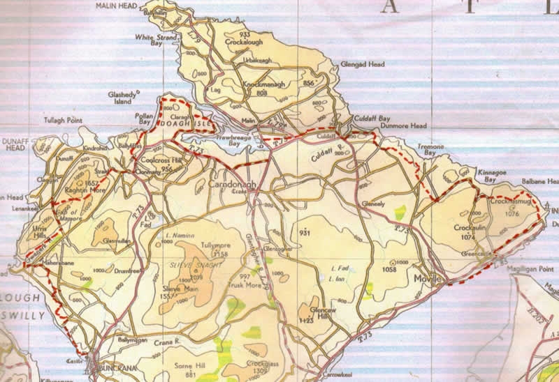
| Route 20 Inishowen Way (Mountainbike Route) This is a cycling version of the Inishowen Way, a conceptual project to walk the Irish coastline from Buncrana to Moville, connecting the two ferries. The walkers route has been restricted, in that the entire Malin area has been left out, due to chronic access problems, and the mountain bike route has been so diverted to avoid contentious areas. Park near the old bridge over the river Cranagh at GR C344 326. On the far side of this, turn right of Buncrana Castle, and immediately left of O'Doherty’s Keep, on a good footpath, which soon leads down to the shore of Lough Swilly. Follow the concrete coastal path past Ned’s Point, (a Napoleonic Fortress), and Father Hegarty’s Rock, until you reach the beach at Stragill. Please dismount, or display extreme courtesy to pedestrians on this busy path. Cross the beach to GR 325 348, and at the far side, take the road running inland, and go left at the first crossroads, turning right again at the Loreto Convent junction, (Gr 318 356), turning inland, to a minor cross roads at Gr 324 364. Go straight through, uphill, and turn left at the next T junction (at Linsfort), taking the second left, just past Ballyannan Br. Follow this very minor road for a kilometre, and take the first right ,(just after crossing a stream) climbing this lane to a T junction at Gr314 390. Turn left and take the scenic tour of Tonduff Hill (interesting megalithic tomb on top). At the next junction turn right, keep left, and descend to Gr 297 395, where a sharp right is taken, descending, crossing the Owenerk River, and following the delightful road, past Milltown and Carha, which traverses the South Eastern slopes of the Urris Hills. Emerging on the Mamore Gap road, turn left, and a steep climb takes you to the top, rewarding views, and an even more rewarding descent on the other side lead down to a car park at Gr 318 443. The hard work really starts here! Follow the newly surfaced track which wends its way unrelentingly uphill to the col between Mamore Hill and Crockmain. It runs out at the top, but there is a fainter trail leading East to the col between Crockmain and Slievekeeragh, which can be mostly cycled as it is either level or downhill, and there are yellow posts to roughly mark the route. Soon you pick up the Butler's Glen track, which exits onto the road at Glen House (food and refreshments). Turn right, and follow the road into Clonmany. From the square, take the road uphill towards Ballyliffin to a cross roads at Gr 380 473. Turn left, towards Annagh, but keep right, and the road takes you down to the beach at Pollan, Gr 387 495. A grassy track along the back of the beach, makes delightful level pedalling for about 2.5 kilometres, with splendid sea views, to meet the end of a track at Carrickabraghy. The road climbs past the old castle of that name, before descending to Lagacurry (the Craft Village there is worth a visit), with good views over the Lagg (Narrows) and the Knockmany Bens on the other side. Turn inland to Claragh, and descend again to the shore at Doaghmore. This scenic little road follows the coastline around the east side of Doagh Island, with a couple of short hills, to rejoin the main (Well, Mainer!) road at GR 422 498, and then the proper main road at GR 407489 (Lackboy). Turn left, and suffer this relatively busy road (there are no feasible alternatives) for about 5k, turning left onto the slab road at Gr 451 468, which leads to Strawbridge on the R238. Go left, and just as you enter Malin Town, turn right past stables at Gr 471 497, on the south side of the Ballyboe River. This becomes unsurfaced before you cross the R243 Malin/Culdaff road, continue past Cracknagh, onto a minor road which leads into Culdaff village over the bridge, and left to McGrorys Hotel (food and refreshments), just past the village green. Departing from McGrorys, turn left and follow the coastal road (a Sli na Slainte) along the river to GR 536 497, past the beach carpark/ childrens’ playpark at GR 547 497. Follow the coastal road past a caravan park, until it turns right, and at this point (GR 553 497) follow the road back uphill, until it joins the Culdaff/ Carrowmena Road. Turn left, and continue along the road for approx 1.5 kilometres, past some mushroom houses on the right, and turn left again, (approx 30 mins from Culdaff) up a lane to Watch Hill (approx 400 metres after emerging on the road) at GR 562 483. The next section is an intricate network of tracks through “claghans”, some abandoned, some still occupied. The laneway twists through some ruined cottages GR 564 485, joining another lane at GR 566 484, where you turn right, then first left, beside a cottage GR 565 483, to another T junction at GR 569 481. Follow this minor tarmaced lane left (north east) towards Bootog to a right angled turn GR 572 483, and then to another T junction at GR 576 478. Turn left, and continue down to another sharp bend at Crockaveela, after which there are more ruined cottages and a further T junction at GR 582 475. This time, go right, then first left (opposite Tremone sign) at GR 580 475, and continue through the hamlet of Ballycharry, to GR 585 469, where the Darcy Magee path is picked up, leading, over a footbridge, and into the picturesque village of Carrowmena, beside the Tremone Bar, GR 591 462. (On this track there is an ancient slab cross at GR 58763 46816). Turn left through the charming unspoiled village, in a northeasterly direction to a junction at Ballymagaraghy, keep right and continue over the hill to a T junction at the Kinnego Bay Road. Cruise downhill with great views of this superb bay opening up ahead, but at the Trinidad Valencera Memorial. you dog leg back uphill and follow this hilly coastal route (one of the tough sections of the Inishowen 100), turning left out to Craig Gr 640 453. A rough track leads over the hill here, but first you must call at the music house ( the one just past the gate) and ask permission of Mr Anthony McHenry. A small gift of cake or biscuits is always appreciated, as is a few minutes chat! Take McHenry's lane over 2 gates and out onto the hill, where turf cutters tracks lead across Glenane Hill to join a more major track at Gr 656 447. Go left, downhill on the Inishowen Head scenic Loop (badly eroded in places by quads and 4x4s) which leads eventually steeply downhill and left to Stroove. 4k along the coastal road leads into Greencastle. From Greencastle there is a lovely coastal path to Moville, but the first section is currently closed, with no immediate prospect of reopening apparently! It can however be accessed a few hundred metres out the oad towards Moville. It is narrow, and popular with walkers, so take care and show courtesy! Map, OS 1.50,000 sheet 3. |
 Inishowen Way, - Trailbike route |
| Comments |
No Comments have been added so far. |
Route Number: 2763